Projects Overview
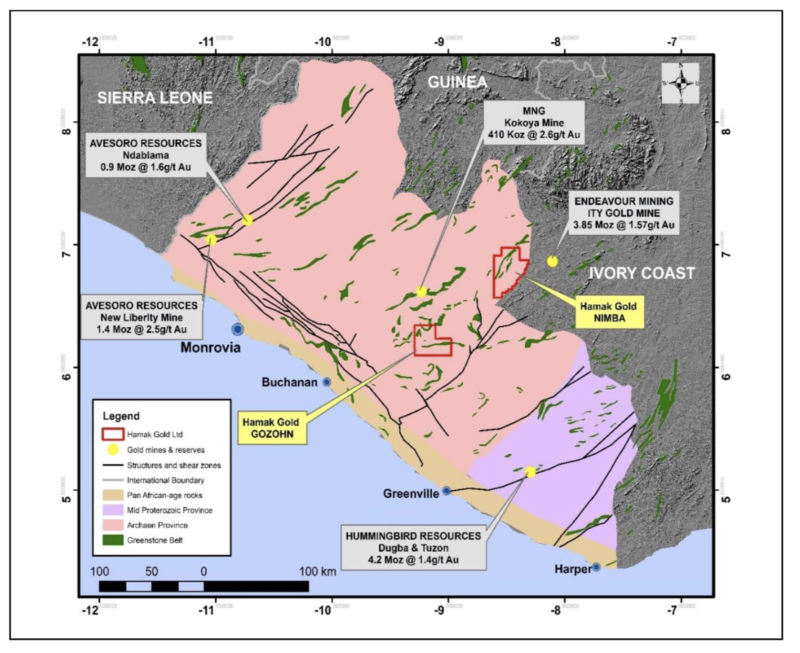
Hamak holds two highly prospective Mineral Exploration Licences (MELs) in Liberia, Nimba and Gozohn, covering a combined area of 1,116 square kilometres. It should be noted that large-scale gold mines have been established in the neighbouring Ivory Coast and our Nimba licence is in relative proximity to the 3.8-million-ounce Ity gold mine of Endeavour Mining, separated by a country border but essentiallysharing the same prospective geology. Equally, MNG’s successful high grade Kokoya gold mine is located some 40 Km to the north of Hamak’s Gozohn licence within similar Greenstone terrain.
At Nimba, following geochemical soil sampling of a number of blocks, an extensive (3km x 1km) strong gold-in-soil anomaly has been defined. Follow up of these anomalies by trenching, channel sampling and rock chip sampling has identified hard rock gold sources for the soil anomalies which host significant high-grade and bulk tonnage gold targets. Drilling at the end of 2022 confirmed a discovery intersection of 20m @ 7 g/t Au near surface. More recently a geophysical survey has been successfully undertaken and additional priority drill targets have been identified.
At Gozohn, significant gold-in-soil anomalies were returned over two areas of Block 1, located in the NW quadrant of the licence, on the western flank of the Mt Koklun greenstone ridge antiform; both extending for 1 to 1.5 km along a northerly strike. Infill soil sampling better defined this coherent anomalous area. Quartz-rich migmatite rock chip samples returned values of 2.56 g/t Au and 3.5 g/t Au and is coincident with one of the strong gold-in-soil anomalies and is proximal to active artisanal mining. Further work, including trenching and drilling, will be required to prove and test the extent of mineralisation within the retained part of this licence.
Nimba licence
Overview
The licence covers 986 km² and is located in Nimba County in north-central Liberia and is accessible along a well-maintained road. Two geologically distinct provenances occur within the licence separated diagonally by NE trending thrust faults. With in the south eastern part of the licence a large metamorphosed intrusive unit contains proven gold mineralization which appears to be associated with the crustal-scale structurally complex NE trending Cestos Shear Zone. The well known 3.8 million ounce Ity gold mine, in neighbouring Côte d’Ivoire, is only some 25 km to the east of the MELs boundary. Intensive artisanal gold mining is observed in many areas of the Nimba licence.
Exploration
Initially exploration work involved geochemical soil sampling of three blocks within the licence area, totalling some 3,622 samples.
The results from Block-1 are highly encouraging with significant coherent gold in soil anomalies generated covering an area of over a 3km x 1km area within which a number of significant anomalous gold values in excess of 1 part per million (“ppm”) (grammes per tonne (“g/t”) are evident at two key locations, which remain open ended to the south-west and north-east.

Importantly the gold in soil values are not constrained within topographic lows but are located on topographic highs. Active artisanal gold mining is present down slope from these two strong gold anomalies.
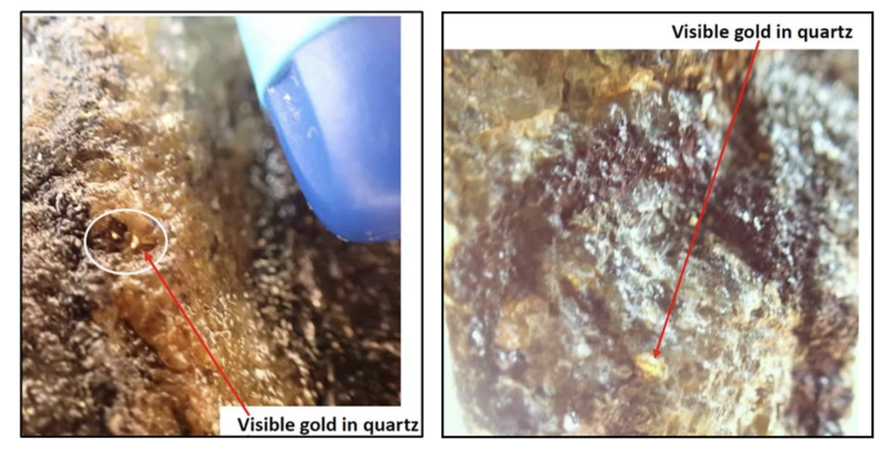
During the soil sampling programme, the exploration teams identified an exposed geological unit at Ziatoyah on the southern edge of the northern soil anomaly, where active artisanal gold mining has and is being undertaken. The unit is described as a metadolerite with visible sulfide mineralization, mainlypyrite, and also visible gold. Rock chip sampling of this unit returned gold values of 37.3g/t Au and 45.5g/t Au, proving the presence of bedrock gold associated with the soil sampling anomaly.
Visible Gold in Metadolerite Unit
Based on the positive rock chip sampling results, channel sampling was undertaken across the metadolerite unit. The results returned gold mineralization across a 66m channel length, which is notclosed off in any direction, with sections of significant gold mineralization returning 55.0m at 0.63 g/t Auand 11.0m at 0.99 g/t Au, which include better intervals of 14m at 1.98g/t Au and 3m at 3.14g/t Au respectively, and with individual samples returning up to 8.56g/t Au over 2m splits. These results areclearly significant in terms of mineralized width and gold grade and provided the basis to develop drilltargets towards defining the extent of the gold mineralization with depth, as well as its lateral extent.
Drilling Programme & Results
An initial programme of diamond drilling, comprising three holes for a total of 450m, was completed at Ziatoyah towards the end of 2022 to test the depth extension of the mineralized metadolerite outcrop. Drilling of holes NZ22-001 and 002 was targeted to test the down dip extent of the Ziatoyah mineralized outcrop that returned highly positive rock chip samples while a 3rd hole (NZ22-003) was targeted on a soil geochemical anomaly located some 1,250m north of the first two drill holes.
The first hole drilled (NZ22-001) yielded significant gold intercepts down hole of 20m at 7g/t Au, including 5m at 22g/t Au confirming the presence of bedrock gold.

Note: Intersections calculated above a 0.3 g/t Au cut-off with no top cut applied and a maximum internal waste interval of 2.0m.

Geology & Mineralization
Initial technical appraisal of the gold mineralization at Ziatoyah suggests that the gold occurs as free grainswithin disseminated crystalline and aggregates of vetiform pyrite attaining levels of between 1% and 10% of the rock mass which is dominated by locally carbonatized metadolerites. Microscopic free gold has been identified at numerous locations within the mineralized drill core. Local shearing appears to enhance the sulphide content and may be coincident with minor endo-skarnification dominated by iron sulphides with free gold, chlorite, epidote, tremolite and/or actinolite.
It is believed that the styles of this gold mineralization bear certain similarities to that currently being mined at Endeavour Mining’s Ity Mine in neighbouring Cote d’Ivoire, only c.25km to the north-east of Ziatoyah, though theCompany is still working on establishing the context of the geology and geological model for the mineralization.
Geophysical Survey & Results
Given the presence of sulphides as the primary host for mineralisation at the Ziatoyah prospect, it was decided to conduct a geophysical survey initially focused on the immediate discovery area (Orientation block) and then to expand outwards to cover part of the extensive gold in soil anomaly (Follow up block).
South African based geophysical consultancy group GeoFocus (Pty) Ltd. was retained to conduct the IP survey. A total of 21 line kilometers of survey were run along traverses varying from 800m to 1,200m with line spacings of 100m and 200m. These lines were chosen to cover the Ziatoyah gold discovery in the vicinity of the significant drill intersection of 20m at 7 g/t Au as well as the northern part of the 3km x 1km strong gold in soil anomaly. An initial IP Orientation/Pilot survey block was surveyed (at 25m and 50m dipole dipole spacing) directly over the Ziatoyah discovery outcrop and Drill Holes 1 and 2 to get the “finger print” of the gold discovery and establish the optimal survey parameters to be applied and conducted over the wider discovery area and northern soil anomaly during the IP Follow Up survey.

GeoFocus reported that the data quality generated from the survey was good, particularly on the 50m dipole dipole transmitter spacing, which provides data to depths of 100m below surface. Processing and interpretation of the data has resulted in the identification of a number of strong IP chargability and resistivity anomalies that can be correlated to the Ziatoyah discovery and the gold in soil anomalies further to the north.
In the image below, a strong chargeability anomaly, at the 75m depth slice, runs from the Ziatoyah discovery site and Drill Hole 1, to the north then curves to the north west. This arcuate strong chargeability anomaly (30 – 40 mSecs) is possibly related to a fold or shear/fault structure. A further two strong chargeability anomalies were identified to the north (circled in black) which correlate well with peak values of gold in soil anomalies.

As previously reported, the gold mineralization intersected at Ziatoyah in drilling and observed in outcrop of the mineralized metadolerite unit suggests that the gold occurs as free grains within disseminated crystalline and aggregates of pyrite attaining levels of between 1% and 10% of the rock mass. The resistivity anomaly in the image below is likely to indicate alteration which is probably associated with sulphide mineralization and shows a strong correlation between gold in soil anomalies and high resistivity readings, including the two northern anomalies.
The interpretation of the IP data has led to the identification of several new priority drill targets to test both the chargeability and resistivity anomalies and to determine whether they represent extensions of the high-grade gold mineralization discovered at the Ziatoyah outcrop and in Drill Hole 1.
The next stage is to design a drilling programme to test these anomalies.

Gozohn licence
Overview
The Gozohn licence (MEL 7002318) formally covered an area of 766 square km and is located within the River Cess and Nimba Counties in central Liberia. The licence is host to a number of structurally controlled greenstone belts similar to those at the nearby high-grade Kokoya Gold Mine, with strongly deformed amphibolite, quartzite, schist and banded ironstone formations which generally occur as topographic highs. Several of these greenstone ridges are mineralized with gold as evidenced by active artisanal gold diggings, particularly on the western slope of Mt. Koklun.
Exploration
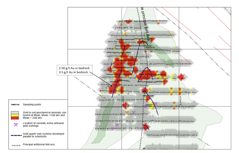
Geological mapping and sampling initially focused on the Mt. Koklun area and 46.5km of baseline and sampling traverse lines were cut and a total of 1,927 soil samples collected across the whole area at a sampling interval of 50m with traverse lines spaced 250m and 500m apart, comprising sample Block- 1.
A second sampling block was completed to the south of the Gozohn licence across similar greenstone belt geology, with a total of 701 samples being collected and assayed. Both blocks are shown in the image below.

Significant gold anomalies were returned over two areas of Block-1 on the western limb of Mt Koklun, one extending over a 1.5km distance having a roughly northerly strike, another extending over a 1km distance and having a roughly north westerly strike, with both anomalies converging in the north. Weaker gold anomalies were detected on the eastern limb of Mt Koklun which require further investigation.

During the soil sampling campaign, a number of rock chip samples were collected and assayed. One sample of quartz-rich migmatite returned a value of 2.56g/t Au and a second rock chip sample from a nearby location returned 3.5g/t Au. These samples coincide with a strong gold in soil anomaly and are proximal to active artisanal mining. A number of these quartz veins are observed in artisanal diggings associated with the soil sampling anomaly.
A soil sampling infill programme, comprising an additional 373 soil samples at 50m sample spacing was completed and better defined the already known coherent anomalous area. These results are presented below with some structural geological interpretation.
Geology & Mineralization
After a detailed review of the geochemical soil anomalies, geology, and occurrence of mineralized quartz veins, it is concluded that the auriferous quartz stringers would seem to have a primary mineralogy dominated by iron sulphides (Pyrite), native gold associated with minor Au-tellurides and selenides. Most of the positive soil geochemistry suggests that the mineralization is concentrated on the western limb of the Mr. Koklun antiform suggesting a structural asymmetry due to E to W sinistral compression. The auriferous quartz veins observed are generally 5-10cms in true thickness; thus, the economic potential will depend on the grade within the quartz structures being able to carry barren wall rock and the frequency of the auriferous veins and further work (including drilling) will be required to determine this.
Licence Reduction
On the anniversary of the licence in 2022, and based on the exploration results to date, it was decided to relinquish the southern part of the Gozohn licence and retain the northern part which hosts the Mt. Koklun greenstone belt and anomaly. The retained area of the Gozohn licence now covers 129.6 square km as shown below.
